
- within Strategy topic(s)
The District of Columbia's Office of Planning (OP) filed a report on July 21, 2025, for Zoning Commission Case No. 25-13, proposing a comprehensive rezoning of the upper Wisconsin Avenue corridor between Friendship Heights and Tenleytown. The amendments are designed to implement the Wisconsin Avenue Development Framework (WADF) and 2021 Comprehensive Plan, with a focus on equitable housing growth, transit-oriented development and high-quality urban design.
A New Zoning Framework for a Changing Corridor
The proposal introduces four new zone districts, each tailored to the corridor's unique context and proximity to Metro stations. These new zones replace a patchwork of outdated designations with a more coherent and predictable regulatory structure that better aligns with the Comprehensive Plan and the WADF. Importantly, the new zones are also intended to facilitate matter-of-right development. If the Zoning Commission approves the rezoning, projects with compliant designs can proceed without undergoing a discretionary zoning review process, offering greater certainty and efficiency for property owners, developers and the community. A general overview of the four new zones, locations and relevant development standards is provided below:
- Friendship Heights Metro Mixed-Use Zone (MU-10/FHM). High-density mixed-use zoning with a maximum height of 130 feet and a maximum density of 7.8 floor area ratio (FAR) (IZ+). Designed to support residential and retail development near the Friendship Heights Metro station. Applies to properties generally fronting the west side of Wisconsin Avenue, the east side of Western Avenue, along the alley north of Harrison Street and east of 45th Street NW.
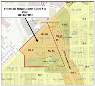
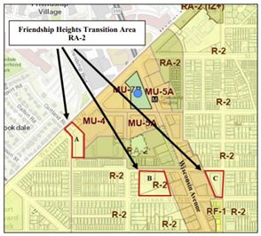
- Friendship Heights Transition Area (RA-2). A moderate-density residential zone intended to serve as a transition between high-density development and adjacent low-density neighborhoods. The zone permits a maximum building height of 50 feet and a maximum density of 1.8 FAR for all structures other than public libraries, or up to 2.16 FAR for IZ developments. The RA-2 zone would apply to three areas: 1) properties fronting 45th Street between Western Avenue and the alley north of Harrison Street NW, 2) properties west of the commercial area along Wisconsin Avenue, between Harrison Street, Garrison Street and the alley, and 3) properties east of the commercial area along Wisconsin Avenue, between Harrison Street, Garrison Street and 42nd Street NW.
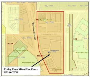
- Tenleytown Metro Mixed-Use Zone (MU-10/TTM). A slightly lower-density mixed-use zone focused on Tenleytown. This zone permits a maximum height of 110 feet and a maximum density of 7.2 FAR (IZ+), with strong design controls to ensure compatibility with surrounding areas. Applies to properties generally fronting Wisconsin Avenue between Chesapeake Street and 40th Street/Fort Drive NW.
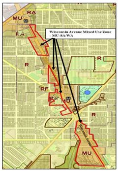
- Wisconsin Avenue Mixed-Use Zone (MU-8A/WA). A midrise zone applied to sites between the two Metro nodes, emphasizing walkability and active ground-floor uses. This zone permits a maximum height of 75 feet and a maximum density of 5.4 FAR (IZ+). Applies to properties generally fronting Wisconsin Avenue between Jennifer Street, Western Avenue and Rodman Street NW.
Design Standards That Shape the Public Realm
OP's report includes comprehensive design requirements that go beyond bulk and use to shape the pedestrian experience and architectural character of new development. Some key design standards proposed for some of the new zones include:
- Setbacks and Stepbacks. Angular plane setbacks (45 degrees) from 90 or 110 feet above the property line are required in the MU-10/FHM and MU-10/TTM zones to reduce visual impacts and preserve light and air.
- Street Wall Requirements. At least 75 percent of the street wall must be built to the property line, with modulation required every 100 feet to avoid long, flat façades.
- Ground-Floor Activation. Ground floors must be at least 15 feet in height and include frequent retail entrances (every 25 to 40 feet, depending on location), with minimum transparency requirements (50 percent).
- Corner Lot Build-To. Buildings on corner lots must extend to all property lines abutting public streets.
- Pedestrian Corridors. Required in key locations (e.g., Squares 1770 and 1733) to improve connectivity between Wisconsin Avenue and side streets. These corridors must be open to the public, uncovered for most of their length and used only for pedestrian-oriented amenities such as outdoor seating or green space.
Equity and Affordability at the Forefront
The amendments apply Inclusionary Zoning Plus (IZ+) across all new zones, a policy tool that increases affordable housing requirements in areas with high land values and limited affordable housing stock. Rock Creek West, which includes the Wisconsin Avenue corridor, has produced just 11.6 percent of its 2025 affordable housing goal. The proposed zoning changes aim to unlock new development capacity while requiring deeper affordability.
The OP report also includes a racial equity analysis, highlighting disparities in income, homeownership and access to opportunity. The zoning changes are framed as a tool to address these inequities by enabling more inclusive growth.
What's Next?
OP presented the proposed map and text amendments to the Zoning Commission at its public meeting on July 31, 2025. The Commission voted to set the case down for a public hearing, which will be scheduled in the coming months.
Final Thoughts
For property owners, the community and development professionals, the proposed amendments offer both opportunity and complexity. The new zones provide greater development potential near transit, but also introduce detailed design standards that will require careful navigation and implementation. Early coordination with legal counsel and design professionals will be essential to ensure compliance and maximize project viability.
The content of this article is intended to provide a general guide to the subject matter. Specialist advice should be sought about your specific circumstances.


